
MANTIS Publications
2023

Sentinel-1 InSAR-derived land subsidence assessment along the Texas Gulf Coast
Xiaojun Qiao, Tianxing Chu, Philippe Tissot & Seneca Holland
International Journal of Applied Earth Observation and Geoinformation
Classification of Terrestrial Lidar Data Directly From Digitized Echo Waveforms
Mohammad Pashei, Michael J. Starek, Craig L. Glennie & Jacob Berryhill
IEEE Transactions on Geoscience and Remote Sensing

Application of Semantic Image Segmentation for Efficient UAS-SfM Photogrammetry Mapping
Mohammad Pashei, Michael J. Starek & Jacob Berryhill
2023 IEEE International Geoscience and Remote Sensing Symposium

Vertical land motion monitored with satellite radar altimetry and tide gauge along the Texas coastline, USA, between 1993 and 2020
Xiaojun Qiao, Tianxing Chu, Philippe Tissot, Ibraheem Ali & Mohamed Ahmed
International Journal of Applied Earth Observation and Geoinformation

Impact of Different GNSS Solutions on UAS-SfM Vertical Accuracy for Shoreline Charting
José Pilartes-Congo, Michael J. Starek & Jacob Berryhill
2023 IEEE International Geoscience and Remote Sensing Symposium
Coastal Subsidence Analysis Between Houston and Galveston, Texas, USA
Xiaojun Qiao, Tianxing Chu & Philippe Tissot
2023 IEEE International Geoscience and Remote Sensing Symposium

Implementation of a Zed 2i Stereo Camera for High-Frequency Shoreline Change and Coastal Elevation Monitoring
José Pilartes-Congo, M. Kastl, Michael Starek, Marina Vicens-Miquel & Philippe Tissot
2023 IEEE International Geoscience and Remote Sensing Symposium
MANTIS Publications
2022

Integrated coastal subsidence analysis using InSAR, LiDAR, and land cover data
Wen Zhong, Tianxing Chu, Philippe Tissot, Zhenming Wu, Jie Chen & Hua Zhang
Remote Sensing of Environment

Chapter 10: Aerial Surveying Technology
Michael J. Starek & Benjamin E. Wilkinson
Chapter in Surveying and Geomatics Engineering: Principles, Technologies, and Application, Manual of Practice (pp. 341-392)

VirtuaLot—A Case Study on Combining UAS Imagery and Terrestrial Video with Photogrammetry and Deep Learning to Track Vehicle Movement in Parking Lots
Bradley Koskowich, Michael J. Starek & Scott A. King
Remote Sensing
Land Subsidence Estimation With Tide Gauge and Satellite Radar Altimetry Measurements Along the Texas Gulf Coast, USA
Xiaojun Qiao, Tiaxing Chu, Philippe Tissot, Jason Louis & Ibraheem Ali
IEEE Geoscience and Remote Sensing Letters

Mapping and Evaluation of Land Deformation with InSAR and GNSS Measurements Near Houston, Texas, USA
Xiaojun Qiao, Tianxing Chu, Philippe Tissot & Jason Louis
2022 IEEE International Geoscience and Remote Sensing Symposium
Full-Waveform Terrestrial Lidar Data Classification Using Raw Digitized Waveform Signals
Mohammad Pashei, Michael J. Starek & Jacob Berryhill
2022 IEEE International Geoscience and Remote Sensing Symposium
MANTIS Publications
2021

Terrestrial Lidar Data Classification Based on Raw Waveform Samples Versus Online Waveform Attributes
Mohammad Pashaei, Michael J. Starek, Craig L. Glennie & Jacob Berryhill
IEEE Transactions on Geoscience and Remote Sensing

Development of a Best Practices Workflow for Rapid Beach Surveying Using a Lower-Cost Mobile Lidar System
Isabel A. Garcia & Michael J. Starek
2021 IEEE International Geoscience and Remote Sensing Symposium (IGARSS)

Full-Waveform Terrestrial Lidar Data Classification Using Raw Samples of Digitized Waveform
Mohammad Pashaei, Michael J. Starek, Philippe Tissot & Jacob Berryhill
2021 IEEE International Geoscience and Remote Sensing Symposium (IGARSS)

UAS-SFM and Airborne Lidar to Measure Hurricane Impacts and Short-Term Recovery Along Little St. George Island, FL, USA
Kelsi L. Schwind, Michael J. Starek & Megan Lamb
2021 IEEE International Geoscience and Remote Sensing Symposium (IGARSS)

Case study of UAS videography for depth inversion within a shallow water surf zone along the Texas Gulf Coast
Larissa M. Freguete, Michael J. Starek & Jacob Berryhill
Remote Sensing of the Ocean, Sea Ice, Coastal Waters, and Large Water Regions

Mapping with LIDAR and structure-from-motion photogrammetry: accuracy assessment of point cloud over multiple platforms
Larissa M. Freguete, Tianxing Chu & Michael J. Starek
Remote Sensing Technologies and Applications in Urban Environments VI

Simulation and characterization of wind impacts on sUAS flight performance for crash scene reconstruction
Tianxing Chu, Michael J. Starek, Jacob Berryhill, Cesar Quiroga & Mohammad Pashaei
Drones

Evaluating the Performance of sUAS Photogrammetry with PPK Positioning for Infrastructure Mapping
Conor McMahon, Omar E. Mora, & Michael J.Starek

Extracting Camera Pose Using Single Image Super Resolution Networks
Bradley Koskowich & Michael J. Starek

Mobile and Airborne Lidar Scanning of Beach Elevation Change Due to Hurricane Harvey
Isabel A. Garcia, Michael J. Starek, & Tianxing Chu

Surfzone Bathymetry Estimation Using Wave Characteristics Observed by Unmanned Aerial Systems
Jesse McDonald, Jason Pollard, Michael J. Starek, & Dulal Kar.

Land Subsidence with tide Gauge, Radar Altimetry and GNSS: A Case Study at Subsiding Coast in Texas
Xiaojun Qiao, Tiaxing Chu, Philippe Tissot & Jason Louis
Proceedings of the 34th International Technical Meeting of the Satellite Division of The Institute of Navigation (ION GNSS+ 2021)
MANTIS Publications
2020

Viewshed simulation and optimization for digital terrain modelling with terrestrial laser scanning
Michael J. Starek, Tianxing Chu, Helena Mitasova, & Russel S. Harmon.
Deep Learning-Based Single Image Super-Resolution: An Investigation for Dense Scene Reconstruction with UAS Photogrammetry
Mohammad Pashaei, Michael J. Starek, Hamid Kamangir, & Jacob Berryhill

Logistical and technical considerations for the use of unmanned aircraft systems in coastal habitat monitoring: A case study in high-resolution subaquatic vegetation assessment
Zachary Olsen, Faye Grubbs, Michael J. Starek, Emma Clarkson, & Jacob Berryhill

Using Lidar Data to Assess the Relationship Between Beach Geomorphology and Kemp’s Ridley (Lepidochelys kempii) Nest Site Selection Along Padre Island, TX, United States
Michele Culver, James C. Gibeaut, Donna J. Shaver, Philippe Tissot, & Michael J. Starek

FloodSim: Flood Simulation and Visualization Framework Using Position-Based Fluids
I. Alihan Hadimlioglu, Scott A. King, & Michael J. Starek

Review and Evaluation of Deep Learning Architectures for Efficient Land Cover Mapping with UAS Hyper-Spatial Imagery: A Case Study Over a Wetland
Mohammad Pashaei, Hamid Kamangir, Michael J. Starek, & Philippe Tissot
MANTIS Publications
2019

Fully Convolutional Neural Network for Land Cover Mapping In A Coastal Wetland with Hyperspatial UAS Imagery
Mohammad Pashei & Michael J. Starek
2019 IEEE International Geoscience and Remote Sensing Symposium

Assessing VIs Calculated From UAS-Acquired Multispectral Imaging to Detect Iron Chlorosis in Grain Sorghum
Isabel A. Garcia, Michael J. Starek & Michael J. Brewer
2019 IEEE International Geoscience and Remote Sensing Symposium

Application of Unmanned Aircraft Systems for Coastal Mapping and Resiliency
Michael J. Starek, Melanie Gingras & Gary Jeffress
Pages 109-125
“Meeting the spatial needs of the third coast”
Melanie Gingras & Michael J. Starek
MANTIS Publications
2018

Characterizing canopy height with UAS structure-from-motion photogrammetry—results analysis of a maize field trial with respect to multiple factors
Tianxing Chu, Michael J. Starek, Michael J. Brewer, Seth C. Murray, Luke S. Pruter
Remote Sensing Letters
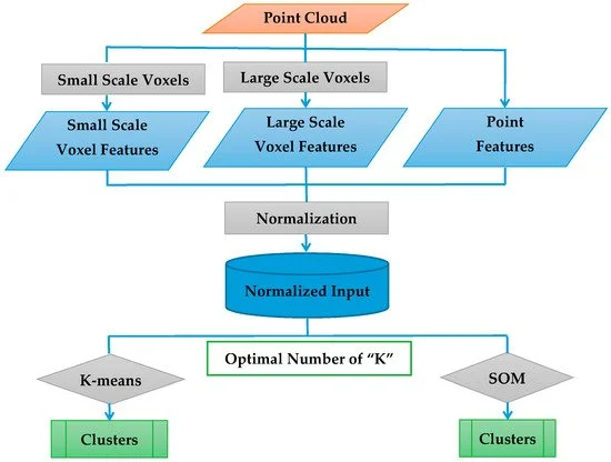
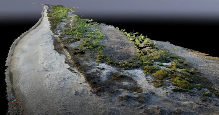
Unsupervised Clustering Method for Complexity Reduction of Terrestrial Lidar Data in Marshes
Chuyen Nguyen, Michael J. Starek, Philippe Tissot & James Gibeaut
Remote Sensing

Evaluation of a Survey-Grade, Long-Range UAS Lidar System: a Case Study in South Texas, USA
Michael J. Starek, Tianxing Chu & David Bridges
2018 IEEE International Geoscience and Remote Sensing Symposium (IGARSS)
MANTIS Publications
2017

Assessing Lodging Severity over an Experimental Maize (Zea mays L.) Field Using UAS Images
Tianxing Chu, Michael J. Starek, Michael J. Brewer, Seth C. Murray, Luke S. Pruter
Remote Sensing

Unmanned aircraft system-derived crop height and normalized difference vegetation index metrics for sorghum yield and aphid stress assessment
Carly Stanton, Michael J. Starek, Norman Elliott, Michael Brewer, Murilo M. Maeda & Tianxing Chu
Journal of Applied Remote Sensing

MULTI-platform UAS imaging for crop height estimation: Performance analysis over an experimental maize field
Tianxing Chu, Michael J. Starek, Michael J. Brewer, Seth C. Murray
2017 IEEE International Geoscience and Remote Sensing Symposium (IGARSS)

UAS imaging for automated crop lodging detection: a case study over an experimental maize field
Tianxing Chu, Michael J. Starek, Michael J. Brewer, Tiisetso Masiane & Seth C. Murray
Autonomous air and ground sensing systems for agricultural optimization and phenotyping II
MANTIS Publications
2016

Cotton growth modeling and assessment using unmanned aircraft system visual-band imagery
Tianxing Chu, Ruizhi Chen, Juan A. Landivar, Murilo M. Maeda, Chenghai Yang & Michael J. Starek
Journal of Applied Remote Sensing