Isabel Garcia-Williams Defends Dissertation

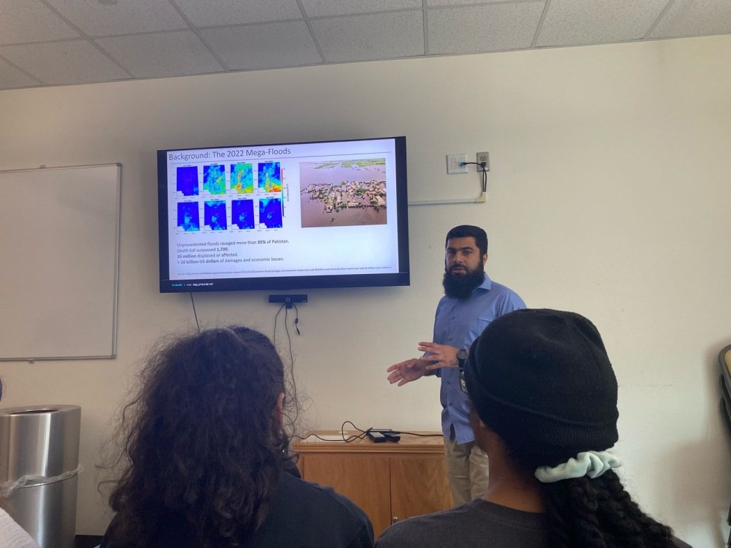
Congratulations to MANTIS and CMSS Ph.D. student Isabel Garcia-Williams for successfully defending her dissertation, titled “Evaluation and Application of Mapping-Grade Mobile Lidar Scanning (MLS) for Coastal Zone Monitoring” on June 26, 2025.

While at MANTIS, Isabel’s research focused on assessing and utilizing a mapping-grade Mobile Lidar Scanning (MLS) system for monitoring sandy beach coastal corridor environments. Before her doctoral journey, Isabel received a Bachelor’s degree in Surveying Engineering with a minor in Mathematics from New Mexico State University and a Master’s degree in Geospatial Surveying Engineering from Texas A&M University-Corpus Christi. We wish her well in her future endeavors.

PRESENTATION ABSTRACT

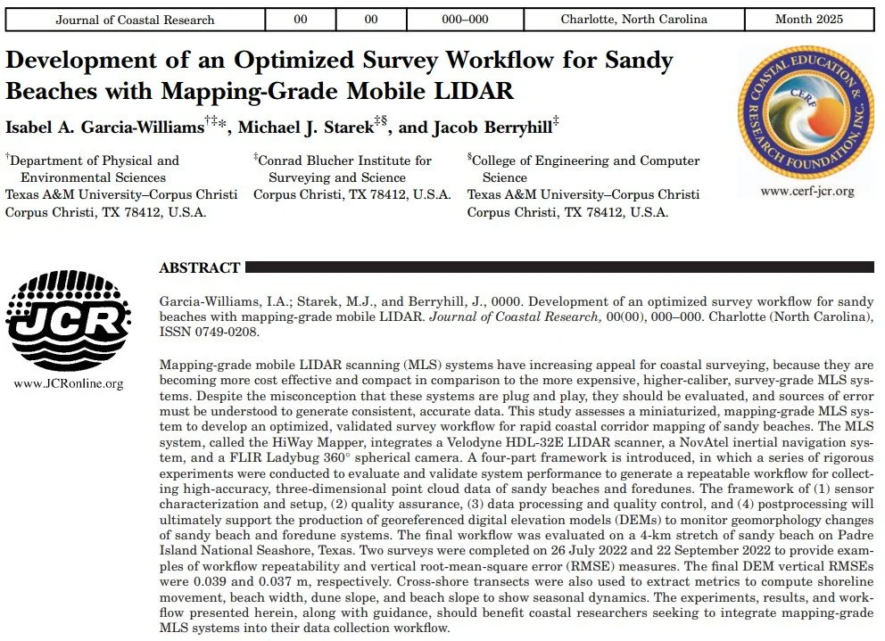
Vehicle-based mapping-grade mobile lidar scanning (MLS) systems collect high-resolution, three-dimensional point cloud data and allow for rapid deployment and flexible operation. They typically integrate a lidar scanner, mobile platform, position and orientation system (POS), camera, control system, and rigid mount. Unlike survey-grade MLS systems, which prioritize high precision, accuracy, and long-range scanning, mapping-grade systems generally integrate less capable lidar sensors and lower-grade POS components, resulting in relatively lower cost and a smaller form factor. These characteristics make mapping-grade MLS particularly useful for rapid deployment in coastal mapping and monitoring applications, where ease of use and mobility are important, and conditions are conducive to vehicle-based scanning. However, these benefits come with potential limitations, including reduced scanning range and lower positional accuracy and precision. Despite these limitations, mapping-grade MLS systems can provide accurate, detailed point cloud data of the beach and lower foredune, enabling the generation of high-resolution digital elevation models (DEMs) to support analysis of beach geomorphology, shoreline dynamics, sediment transport, coastal engineering projects, and post-storm impacts.

This study evaluates the application of a mapping-grade MLS system in sandy beach environments to support mapping and monitoring aimed at informing coastal management decisions. It is structured around three core objectives: (1) development of an optimized survey workflow for MLS system data collection and processing tailored to sandy beach corridors; (2) application of the workflow to assess shoreline position and geomorphic changes on a seawall-adjacent beach at North Padre Island, Texas, to guide bollard placement for vehicle access control and evaluate nourishment performance, including a comparative analysis of MLS and uncrewed aircraft system (UAS) photogrammetry for beach monitoring; (3) application of the workflow to assess seasonal vulnerability of Kemp’s ridley sea turtle (Lepidochelys kempii) nesting beaches along Padre Island National Seashore (PAIS) using an adapted Coastal Engineering Resiliency Index (CERI), supplemented by airborne lidar scanning (ALS) datasets for historical analysis. Overall, this work demonstrates the practical utility of mapping-grade MLS scanning in capturing coastal change and highlights its advantages, limitations, and potential for supporting coastal policy, resiliency planning, and resource management.

Isabel Garcia-Williams Publishes Article in the Journal of Coastal Research

MANTIS Ph.D. Candidate Isabel Garcia-Williams has recently published an article in the Journal of Coastal Research titled "Development of an Optimized Survey Workflow for Sandy Beaches with Mapping-Grade Mobile LIDAR”. The publication presents a refined approach to coastal data acquisition using mobile LiDAR systems, emphasizing efficiency, accuracy, and reproducibility for shoreline monitoring and geomorphic assessments.

——

The abstract reads as follows:

Mapping-grade mobile LIDAR scanning (MLS) systems have increasing appeal for coastal surveying, because they are becoming more cost effective and compact in comparison to the more expensive, higher-caliber, survey-grade MLS systems. Despite the misconception that these systems are plug and play, they should be evaluated, and sources of error must be understood to generate consistent, accurate data. This study assesses a miniaturized, mapping-grade MLS system to develop an optimized, validated survey workflow for rapid coastal corridor mapping of sandy beaches. The MLS system, called the HiWay Mapper, integrates a Velodyne HDL-32E LIDAR scanner, a NovAtel inertial navigation system, and a FLIR Ladybug 360° spherical camera. A four-part framework is introduced, in which a series of rigorous experiments were conducted to evaluate and validate system performance to generate a repeatable workflow for collecting high-accuracy, three-dimensional point cloud data of sandy beaches and foredunes. The framework of (1) sensor characterization and setup, (2) quality assurance, (3) data processing and quality control, and (4) postprocessing will ultimately support the production of georeferenced digital elevation models (DEMs) to monitor geomorphology changes of sandy beach and foredune systems. The final workflow was evaluated on a 4-km stretch of sandy beach on Padre Island National Seashore, Texas. Two surveys were completed on 26 July 2022 and 22 September 2022 to provide examples of workflow repeatability and vertical root-mean-square error (RMSE) measures. The final DEM vertical RMSEs were 0.039 and 0.037 m, respectively. Cross-shore transects were also used to extract metrics to compute shoreline movement, beach width, dune slope, and beach slope to show seasonal dynamics. The experiments, results, and workflow presented herein, along with guidance, should benefit coastal researchers seeking to integrate mapping-grade MLS systems into their data collection workflow.

Dr. Tianxing Chu promoted to Associate Professor of Computer Science

The Texas A&M University System Board of Regents has announced the approval of Dr. Tianxing Chu’s promotion to Associate Professor of Computer Science. Promotion to the rank of Associate Professor is a recognition of the maturity and experience of a faculty member’s professional success as they increase their leadership within the academic profession. Dr. Chu is both a professor in TAMU-CC's College of Engineering and Computer Science and the Associate Director of CBI's Measurement Analytics (MANTIS) Lab. We congratulate Dr. Chu on his esteemed achievements!

TxDOT Highlights MANTIS Research

The Measurement Analytics (MANTIS) Lab at Texas A&M University-Corpus Christi was recently recognized by the Texas Department of Transportation (TxDOT) for its pioneering research on unmanned aircraft systems (UASs) for geospatial data acquisition. The research, funded and supported by TxDOT, was featured at the 2025 ASCE Texas Section Utility Engineering and Surveying Institute (TxUESI) Conference, underscoring the lab’s role in advancing innovation in transportation infrastructure through cutting-edge remote sensing technologies.

The study, formally titled Unmanned Aircraft Systems in Land Surveying: A Comparative Study of LiDAR and Photogrammetry, investigated the capabilities of UAS platforms equipped with digital cameras and light detection and ranging (LiDAR) sensors for surveying and mapping applications. The research focused on evaluating the accuracy, repeatability, and cost-effectiveness of UAS-based structure-from-motion / multi-view stereo (SfM/MVS) photogrammetry (or UAS-SfM) and UAS-LiDAR under varied field conditions. Comprehensive field campaigns were conducted across multiple geographic regions in Texas, assessing the performance of both technologies in diverse terrain types and environmental settings. These trials examined 3D data fidelity, explored different configurations of ground control, and analyzed data processing and post-processing workflows. The study also identified operational strengths and limitations inherent to each approach, providing actionable guidance for the integration of UAS technologies into transportation survey workflows.

During the conference presentation, Ronny Lackey (representing TxDOT) emphasized the study’s significance in supporting TxDOT’s digital delivery initiative. He highlighted the practical value the findings offer to surveyors and engineers statewide, particularly in enhancing the efficiency, safety, and quality of geospatial data collection for transportation projects.

The MANTIS Lab’s collaboration with TxDOT reflects a broader commitment to research-driven solutions that align with the evolving needs of infrastructure development. The full research report is available through the Lab Resources >> Technical Reports on this website.

MANTIS and CBI Support TxUESI Conference

The Measurement Analytics Lab (MANTIS), in collaboration with the Conrad Blucher Institute for Surveying and Science (CBI), played a central role in organizing and supporting the 2025 Texas UESI (TxUESI) Conference, held May 21–23 at Texas A&M University-Corpus Christi.

Hosted on the university's campus, this year’s TxUESI Conference brought together engineers, surveyors, researchers, students, and industry leaders from across Texas to explore emerging trends, technologies, and standards in utility engineering and subsurface investigations. The event featured technical sessions, equipment demonstrations, and professional networking opportunities.

MANTIS researchers and CBI staff were actively involved in the event’s coordination, including the development of session tracks on advanced surveying and sensing methods, digital twin applications, UAS-based data acquisition, and geospatial analytics. The conference also highlighted the critical role of academic-industry partnerships in advancing subsurface utility engineering practices.

The 2025 TxUESI Conference underscored the importance of interdisciplinary collaboration to address infrastructure challenges across Texas and beyond.

Dr. Bradley Koskowich Publishes Article on Exploring Monoplotting for Cross-View Geo-Localization

Former MANTIS student Dr. Bradley Koskowich has recently published an article in the ISPRS Open Journal of Photogrammetry and Remote Sensing titled “The Potential & Limitations of Monoplotting in Cross-View Geo-Localization Conditions.” This publication stems from Dr. Koskowich’s doctoral dissertation research during his time at MANTIS.

——

The abstract reads as follows:

Cross-view geolocalization (CVGL) describes the general problem of determining a correlation between terrestrial and nadir oriented imagery. Classical keypoint matching methods find the extreme pose transitions between cameras present in a CVGL configuration challenging to operate in, while deep neural networks demonstrate superb capacity in this area. Traditional photogrammetry methods like structure-from-motion (SfM) or simultaneous localization and mapping (SLAM) can technically accomplish CVGL, but require a sufficiently dense collection of camera views in order to recover camera pose. This research proposes an alternative CVGL solution, a series of algorithmic operations which can completely automate the calculation of target camera pose via a less common photogrammetry method known as monoplotting, also called single camera resectioning. Monoplotting only requires three inputs, which are a target terrestrial camera image, a nadir-oriented image, and an underlying digital surface model. 2D-3D point correspondences are derived from the inputs to optimize for the target terrestrial camera pose. The proposed method applies affine keypointing, pixel color quantization, and keypoint neighbor triangulation to codify explicit relationships used to augment keypoint matching operations done in a CVGL context. These matching results are used to achieve better initial 2D-3D point correlations from monoplotting image pairs, resulting in lower error for single camera resectioning. To gauge the effectiveness of the proposed method, this proposed methodology is applied to urban, suburban, and natural environment datasets. This proposed methodology demonstrates an average 42x improvement in feature matching between CVGL image pairs, which improves on inconsistent baseline methodology by reducing translation errors between 50%–75%.

José Pilartes-Congo Acquires SIT Certification

MANTIS Ph.D. student José Pilartes-Congo recently acquired his Surveyor-in-Training (SIT) certification in the state of Texas after successfully passing the examination administered by the Texas Board of Professional Engineers and Land Surveyors (TBPELS). This certification marks an important step toward professional licensure and recognizes José’s technical expertise in geospatial and land surveying principles. MANTIS celebrates this accomplishment as a testament to José’s dedication and the group’s continued commitment to advancing excellence in geospatial engineering.

Mohammad Sohail Presents Research at 2025 NSF GAGE/SAGE Community Science Workshop

Congratulations to Mohammad Sohail, MANTIS student in the Computer Science Ph.D. program, who recently presented his research at the 2025 NSF GAGE/SAGE Community Science Workshop in Bloomington, Minnesota. The workshop focused on geophysical research exploring the solid Earth, cryosphere, oceans, atmosphere, and more. While there, Mohammad presented his research on land deformation and risk assessment related to the 2022 Southern Flood Plain in Pakistan event.

MANTIS Hosts Students During NOAA Workshop

The Measurement Analytics Lab (MANTIS) recently welcomed a group of students as part of a National Oceanic and Atmospheric Administration (NOAA) workshop aimed at advancing education and exposure in coastal and geosciences. The visit, held in conjunction with a broader initiative to showcase research facilities across the university, centered on the application of remote sensing technologies for surveying and mapping, with a special focus on coastal studies, change detection, and precision measurement and analytics.

Students engaged in discussions led by MANTIS researchers and observed demonstrations highlighting the lab’s cutting-edge capabilities in remote sensing data acquisition, processing, and analysis. Particular emphasis was placed on techniques for monitoring coastal environments, detecting environmental and anthropogenic changes over time, and ensuring accuracy in spatial data for scientific and operational use.

Dr. Michael J. Starek, Director of MANTIS, also served as a featured speaker during the workshop. In his address, he underscored the critical role of measurement science in contemporary geospatial research, particularly as coastal regions face increasing environmental pressures.

Ahmed Omar Presents Research at the 2025 TAMIDS Scientific Machine Learning (SciML) Summer School

Congratulations to Ahmed Omar, MANTIS student in the Coastal Marine Systems Science Ph.D. program, who recently presented his research and took part in the 2025 TAMIDS Scientific Machine Learning (SciML) Summer School. Held over five days, the program introduced a select group of students to the fundamentals of Physics-Informed Neural Networks (PINNs) and Scientific Machine Learning (SciML).

Nicholas Lincks Graduates!

MANTIS undergraduate student Nicholas Lincks has recently graduated from the Geospatial Science program at TAMUCC. During his time with MANTIS, Nicholas was engaged in remote sensing applications for surveying and mapping and also served as a founding member and president of the ASPRS Student Chapter for Texas A&M University-Corpus Christi. Nicholas will go on to work for Dallas Aerial Mapping as he continues to pursue licensure as an RPLS. We wish him the very best in his future endeavors.

MANTIS Students Present at 2025 SSIRCA

MANTIS students Sabin Pandey, Ahmed Omar, and Mohammad Sohail presented their research at the 2005 Student Symposium for Innovation Research & Creative Activities (SSIRCA) held at Texas A&M University-Corpus Christi on April 25. The presentation titles were as follows:

  • Sabin Pandey: Evaluation of SfM-MVS Apple LiDAR Data for Coastal Monitoring

  • Ahmed Omar: Monitoring Groundwater Levels in Different Texan Aquifers Using Satellite Data, Geologic Inputs and Machine Learning

  • Mohammad Sohail: Satellite-Based Monitoring and Mapping of Disaster Risk: A Case Study of the Southern Flood Plain in Pakistan

The annual symposium serves as a platform for supporting student research and creative work, helping students achieve their academic and career goals. Participation encourages students to showcase their research ideas, discoveries, and creative work and receive meaningful feedback from an evaluation panel of established TAMU-CC faculty members and researchers. Participation also prepares students for presentations at national and international events.

ASPRS Student Chapter Launched at Texas A&M University-Corpus Christi

We are proud to announce that the American Society for Photogrammetry and Remote Sensing (ASPRS) has officially recognized Texas A&M University-Corpus Christi as an ASPRS Student Chapter. This milestone comes after a successful petition led by the MANTIS Lab director and a group of dedicated graduate students passionate about advancing geospatial sciences.

ASPRS is a prominent scientific association committed to the advancement of Remote Sensing, Photogrammetry, and Geographic Information Systems (GIS). With this new chapter, the Island University joins a distinguished network of academic institutions working collaboratively to support the growth and professional development of the next generation of geospatial scientists.

The TAMU-CC ASPRS Student Chapter aims to provide a platform for students to engage in scholarly exchange, technical training, and outreach initiatives. Through workshops, guest lectures, and networking events, the chapter will foster a vibrant community of learners and practitioners devoted to geospatial innovation.

This accomplishment reflects the growing momentum of geospatial research and applied technology on campus, particularly through initiatives led by the MANTIS Lab. We look forward to the chapter’s contributions in shaping coastal, environmental, and urban research through state-of-the-art remote sensing and photogrammetric methodologies.

For more information, visit our official ASPRS chapter page and view the announcement on LinkedIn.

Benjamin Ghansah Publishes in Computers and Electronics in Agriculture

MANTIS Ph.D. student Benjamin Ghansah has recently published an article in Computers and Electronics in Agriculture titled “Satellite vs Uncrewed Aircraft Systems (UAS): Combining High-Resolution SkySat and UAS images for Cotton Yield Estimation.” The manuscript explores how imagery from a high-resolution satellite system (SkySat) compares with imagery captured by UAS platforms for the purpose of estimating cotton yield. The dataset was collected over cotton fields in Texas during the 2023 growing season. A range of vegetation indices (including NDVI, GCI, MSR) were derived from both satellite and UAS images and used as inputs to a multilayer perceptron (MLP) deep-learning model, with observed yield data (lint + seed) serving as the response variable.

——

The abstract reads as follows:

Uncrewed Aircraft Systems (UAS) are widely used for crop growth monitoring and yield estimation in Precision Agriculture (PA). However, UAS are limited by their relatively small area coverage, high cost, and high data processing needs. High resolution satellites (such as SkySat) are valuable alternatives to UAS in PA. Nonetheless, persistent cloud cover, especially in regions like the South of Texas, limits their utility. This study compared and explored the integration of satellite and UAS imagery for cotton yield estimation. The rationale was to determine the best performing platform among the two, as well as leverage their synergy to mitigate data gaps caused by persistent cloud cover. Using deep learning model, vegetation indices derived from SkySat and P4M (Phantom 4 Multispectral) images were correlated with crop yield data collected during the 2023 season. Results demonstrated that SkySat slightly outperformed P4M in yield estimation, with median accuracies of R2 = 0.81 and RMSE = 0.20 ton/ha for SkySat, compared to R2 = 0.80 and RMSE = 0.21 ton/ha for P4M. More importantly, when all the SkySat and P4M datasets were combined, accuracy improved by 3% compared to SkySat-only data. In addition, data collected between 74 and 114 days after planting contributed most significantly to yield prediction. The fusion approach used in this study allows for better spatial and temporal coverage, ultimately enhancing yield prediction reliability in PA. Future research should explore the inclusion of additional sensors such as Synthetic Aperture Radar (SAR) and thermal imagery, which could further improve yield prediction accuracy, especially in cloud-prone regions.

MANTIS and TTI Collaborate on GNSS Evaluation

The Measurement Analytics (MANTIS) Laboratory recently joined forces with the Texas A&M Transportation Institute (TTI) for a hands-on geospatial research experiment aimed at advancing the understanding of specific GNSS technologies. This collaborative effort brought together researchers and engineers from both teams to conduct a comparative field study of GNSS receiver performance across various grades and correction techniques.

The joint fieldwork took place on the Texas A&M University campus, where teams collected GNSS data over a known benchmark. The objective was to evaluate the feasibility, limitations, and practical applications of different GNSS configurations in the context of geospatial sciences, surveying and mapping, and transportation-related projects. By comparing the different setups, the researchers seek to quantify positional accuracy, reliability under varying environmental conditions, and overall cost-effectiveness.

Key considerations included accuracy and precision (how close each receiver-correction pair could measure relative to the benchmark), operational complexity (time, setup, and training required to deploy each system), and cost benefit (balancing budget constraints with positional accuracy needs). Findings are expected to inform best practices for selecting GNSS technologies based on project requirements, whether for asset inventory, roadway mapping, traffic infrastructure planning, or other geospatial applications where precise positioning is critical.

This collaboration underscores the value of interdisciplinary research and practical testing as MANTIS and TTI continue to bridge engineering and geospatial science to support innovation in transportation systems and beyond.

MANTIS Faculty and Students Present Research at ASPRS Gulf South Conference

MANTIS faculty and students recently attended the American Society for Photogrammetry and Remote Sensing (ASPRS) Gulf South Conference, held March 13-15 in Austin, Texas. The event provided an opportunity for researchers to share advancements in remote sensing and geomatics, particularly in the areas of UAS-SfM photogrammetry, LiDAR, artificial intelligence, and InSAR applications. The MANTIS team contributed to the discussion with several compelling presentations, each exploring innovative methods to enhance surveying, mapping, and geospatial analysis.

MANTIS director, Dr. Michael J. Starek delved into the role of artificial intelligence and deep learning in UAS photogrammetric workflows. His research highlights how AI-driven automation can significantly enhance data processing, feature extraction, and accuracy assessment in aerial photogrammetry. The ability to integrate deep learning into these workflows paves the way for more efficient and scalable mapping solutions, reducing manual labor while improving the quality of 3D reconstruction. MANTIS associate director, Dr. Tianxing Chu (joined by CBI’s research scientist, Dr. Danielle Smilovksy), provided insights into InSAR technology, emphasizing its applications for infrastructure monitoring, land subsidence detection, and disaster response. Their presentation addressed the current capabilities of InSAR and how emerging advancements in satellite-based remote sensing will further improve the technology’s ability to monitor surface deformation with high accuracy.

Graduate students Benjamin Gansah, Jose Pilartes-Congo, and Sabin Pandey also presented their research. Benjamin introduced his research on the integration of remote sensing and machine learning for agricultural monitoring. His work leverages advanced image processing and classification techniques to assess crop health and yield predictions. By combining remote sensing data with machine learning models, his study provides a pathway for smarter, data-driven agricultural decision-making, addressing challenges such as food security and resource optimization. Jose presented a study comparing UAS-SfM photogrammetry and UAS-LiDAR for material volume estimation. His research aimed to determine which method offers greater accuracy and efficiency in measuring material volumes. By evaluating the strengths and limitations of both techniques, his findings contribute to the ongoing optimization of remote sensing workflows. Finally, Sabin discussed his research on the accuracy of Apple lidar scanning patterns using the SfM/MVS photogrammetry techniques. His research focused on assessing how well Apple’s mobile lidar systems perform compared to traditional UAS-SfM photogrammetry approaches. He also explored the potential for data fusion between Apple lidar and UAS imagery, which could open new possibilities for cost-effective, high-resolution 3D mapping applications.

The MANTIS research group continues to push the boundaries of geospatial science, developing methodologies that improve the accuracy, efficiency, and scalability of remote sensing applications. Their work at the ASPRS Gulf South Conference reflects their ongoing commitment to advancing the field and contributing to real-world solutions in surveying, mapping, and environmental monitoring. As remote sensing technology evolves, the MANTIS team remains at the forefront, driving innovation for both academic research and industry applications.

Naval Research Lab Representatives Visit MANTIS

In a recent visit to the Conrad Blucher Institute, representatives from the Naval Research Laboratory (NRL) spent some time in the MANTIS Laboratory for a brief discussion on the latest advancements in remote sensing technologies and artificial intelligence (AI) for surveying and mapping. The visit focused on the various ways in which MANTIS researchers are exploring cutting-edge methodologies to enhance 3D data collection and geospatial analysis, with focus on coastal monitoring. During the visit, the MANTIS team presented their ongoing projects, demonstrating how remote sensing techniques are being integrated with AI to improve data collection, processing, and analysis. The discussion highlighted the application of these technologies for coastal surveying, asset monitoring, and long-term management.

TAMUCC Alumni Inspire Future Land Surveyors

During a recent recruitment visit to Texas A&M University-Corpus Christi (TAMUCC), former students, Juan Martinez (‘17), Luis Hernandez (‘17), and Dustin Pustejovski (‘14), who are now professionals at Westwood Professional Services, Inc., returned to share their insights and experiences in the land surveying profession. The visit provided a valuable opportunity for current students to connect with industry professionals and learn about the latest advancements in the field. The alumni engaged with students, former colleagues, and instructors, offering firsthand perspectives on their career paths and the evolving landscape of land surveying. Their experiences highlighted the practical applications of their education and the diverse opportunities available within the profession.

A key highlight of the discussion was the integration of cutting-edge technology in modern land surveying practices. The former students showcased how they are using advanced 3D laser scanning and UAS photogrammetry in their projects. These technologies are transforming the industry by enhancing precision, efficiency, and data collection capabilities in various surveying applications. The visit not only served as an informative session for students but also as an inspiring moment for faculty and staff, reinforcing the importance of real-world applications in academic learning. By bridging the gap between education and professional practice, these engagements help students better prepare for their careers and stay informed about industry trends.

Celebrating Dr. Bradley Koskowich's Graduation

Dr. Bradley Koskowich became the latest MANTIS and Geospatial Computer Science program graduate this past December 14, 2024. This is a well-deserved accomplishment for a student who has gone through the geospatial undergraduate and graduate programs at TAMUCC. During his time as a doctoral student, Bradley published several journal and conference papers focused on remote sensing and computer vision techniques for various geospatial applications. We wish Bradley all the best in his future endeavors.

José Pilartes-Congo Defends Dissertation Proposal

MANTIS Ph.D. student José Pilartes-Congo recently defended his dissertation research proposal titled “Change Detection and Digital Twin Generation from Multi-Sensor and Multi-Scale 3D Data Fusion”.

——

His abstract read as follows:

Reality capture technologies incorporating 3D scanning and imaging techniques provide innovative and efficient means for measuring the geometric characteristics of built and natural environments. Common techniques include structure-from-motion / multi-view stereo (SfM/MVS) photogrammetry and lidar scanning, which provide dense and informative 3D point clouds, textured meshes, and digital elevation models (DEMs) that can be used to create digital records and repositories of geospatial data, thus supporting surveying and mapping efforts. These methods can be implemented on various remote sensing platforms such as uncrewed aircraft systems (UASs), traditional aircraft, or satellites to offer different extents of coverage, spatial resolution, and measurement accuracies. By facilitating accurate and effective monitoring of structural and environmental changes over time, these techniques can support a wide range of tasks such as project planning, asset management, and natural resource allocation. However, to effectively do so requires determining how to best exploit information captured in 3D data streams acquired from various remote sensing modalities, while addressing differences in data characteristics, measurement fidelity, and task suitability for different applications. This research explores the following question: How can reality capture (i.e., remote sensing) technologies providing 3D geospatial data at different perspectives, resolutions, geographical extents, and measurement fidelities be effectively and optimally integrated to support structural change detection and monitoring of built and natural environments? This research acknowledges that individual remote sensing modalities for acquiring 3D geospatial data have various advantages and limitations and examines ways to optimally fuse different datasets in a way that one complements the other, resulting in more informative and useful 3D geospatial datasets for change detection applications. With this consideration, this research explores data acquired from ground, air, and space, using photogrammetry and lidar scanning technologies, as well as associated algorithmic and processing techniques for data calibration, georeferencing, accuracy assessment, and data fusion for generating 3D digital twins of the environment. Ultimately, the research seeks to develop a digital twin framework able to ingest multi-sensor, multi-scale 3D data at different spatial resolutions and temporal frequencies, for geospatial change detection analyses to support surveying and monitoring activities, especially for transportation roadway corridors (built environments) and dynamic coastlines (natural environments).